As global temperatures rise and heatwaves become more frequent, cities face a growing challenge: how to protect residents from dangerous heat exposure in public spaces. While climate policy often focuses on air temperature or average cooling effects, heat is experienced most directly where people walk, wait, and gather.
New research led by AMS Institute, MIT Senseable City Lab, TU Delft, Hong Kong Polytechnic University, and Wageningen University & Research has revealed that shade is unevenly distributed across cities. Rather than functioning as a shared public good, shade on sidewalks often follows income and historic patterns of investment, leaving lower-income and peripheral neighborhoods significantly more exposed during the hottest hours of the day.
Published in Nature Communications on 10 February 2026 under the title Global patterns of inequality in pedestrian shade provision, the study is the first to assess pedestrian-scale shade inequality across nine cities worldwide using high-resolution simulations of how buildings and trees cast shade throughout the day.
“Shade is not always distributed where it is needed most. Instead, it is often concentrated in wealthier neighborhoods, while public spaces in lower-income and peripheral areas remain significantly more exposed to heat.”
Lukas Beuster
Research Fellow

The central finding is simple but consequential: shade is not distributed according to need. It reflects long-standing decisions about urban form, land use, and investment in the built environment. As a result, communities that rely on walking and public space the most are often those with the least protection from direct solar radiation.
How shade is produced in cities
Urban shade comes from two primary sources: Buildings and trees. Building shade (often referred to as "grey shade") is a by-product of urban form, shaped by building height, density, street width, and orientation. Tree shade (or “green shade") depends on planting decisions, canopy maturity, and long-term maintenance.
The study shows that these two sources play different roles across cities and times of day. In dense historic centers, buildings can provide substantial shade in the morning and afternoon. At midday, when the sun is highest, trees often become a critical source of protection for pedestrians. Importantly, neither source of shade is distributed randomly. Both reflect decades of planning priorities and incremental investment decisions.
Shade inequality as a political outcome
Across all nine cities analyzed, lower-income neighborhoods receive significantly less shade on pedestrian pathways than wealthier areas. This matters because these same communities are often more vulnerable to heat due to smaller and older homes, limited access to cooling, and a greater reliance on walking and public transport.
By mapping shade specifically onto sidewalks and walkable areas, the project captures heat exposure as a lived experience rather than an abstract environmental indicator. Historical planning decisions continue to shape present-day exposure, turning shade into a political outcome embedded in the physical structure of the city.
“Most urban climate policies focus on average temperatures or general green coverage. By measuring shade where people actually move, wait, and walk, we see a very different picture of who is protected and who is exposed.”
Lukas Beuster
Research Fellow
Amsterdam: A case study in precision planning
Unlike many world cities, Amsterdam represents the gold standard for how detailed data can inform climate policy because it maintains a detailed register of all public surfaces, allowing researchers to map shade onto actual registered sidewalks, capturing conditions where people are truly walking.
The analysis shows that while parts of Amsterdam’s historic center benefit from grey shade due to its compact urban layout, large areas of the city remain poorly shaded during peak heat hours. More recently developed districts, including former harbor areas and peripheral areas, show particularly low levels of protection from direct sun.
These findings confirm that historical urban form can provide incidental shade, but that this alone is insufficient to meet our contemporary heat adaptation needs. High-resolution simulation makes it possible to identify exactly where shade deficits persist, enabling targeted and evidence-based intervention.
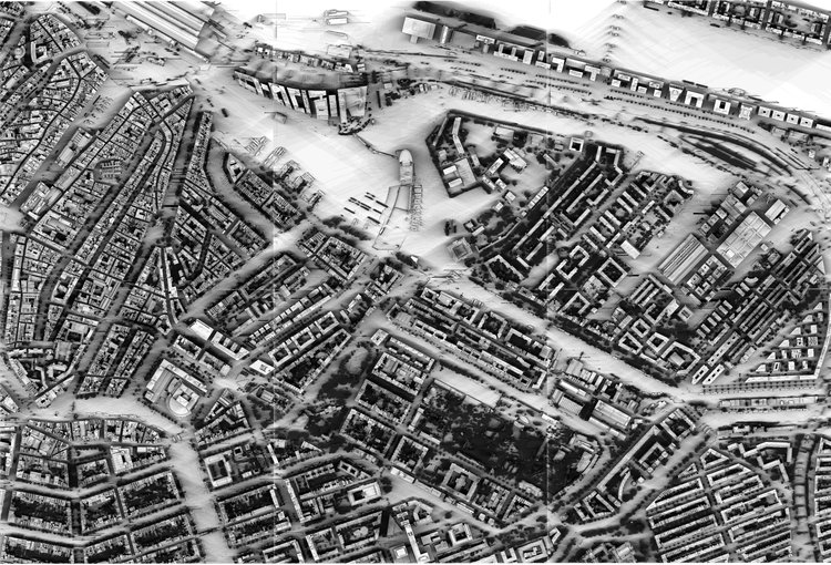
A day of shade in Amsterdam. This visualization traces how shadows shift across streets and public space over the course of a summer day, revealing when and where people are protected from the sun.
Why pedestrian-scale shade matters
Many climate adaptation strategies focus on reducing air temperature, yet research shows that Mean Radiant Temperature (MRT), which is largely driven by direct and reflected solar radiation, is a more decisive factor for thermal comfort, heat stress and increases in mortality. Shade directly reduces MRT and can dramatically improve perceived comfort without altering ambient air temperature.
By focusing on pedestrian-scale shade, the study reframes heat adaptation as an issue of public space quality and accessibility. Shade determines who can safely move through the city, who can comfortably wait for public transport, and who can use the streets during increasingly frequent heatwaves.
From inequality to action
The findings of this study have clear implications for policy and planning. If shade is unevenly distributed and closely tied to vulnerability, then addressing heat risk requires more than general greening targets. It requires measuring shade where people exist in public spaces, and prioritising interventions where exposure is highest.
Rather than prescribing a single solution, the research points toward several emerging directions for climate-adaptive urban design:
- Setting explicit shade targets for pedestrian infrastructure, alongside existing mobility and safety standards.
- Using spatially explicit shade assessments to identify exposed sidewalk segments and guide targeted investment.
- Designing tree planting and street profiles to ensure canopies can mature into effective sources of shade.
- Treating shade as a public health and equity concern, not only as an aesthetic or environmental amenity.
Together, these directions suggest that the shade gap is solvable, but only if cities move from abstract climate goals toward spatially explicit, pedestrian focused adaptation.
Building on this research, ongoing work at AMS Institute and the MIT Senseable City Lab is exploring how pedestrian-scale shade analysis can be translated into practical planning frameworks. This includes developing clear indicators for shade availability, identifying priority intervention areas at sidewalk level, and supporting municipalities in setting explicit, evidence-based shade targets, complementing rather than replacing existing climate adaptation strategies.