Introduction
Information and telecommunication technologies play a growing role in the mobility ecosystem. Cars, public transport, Mobility-as-a-Service and, ultimately, people are more and more connected within a joint ecosystem, with lightning-fast information exchange. This allows us to tackle fundamental challenges in our built environment, such as traffic congestion, noise, pollutant emissions, etc. from a previously unthinkable perspective: dynamically.
Geo-fencing is such a technology: an invisible, digital wall, which allows to define geographical borders, flexibly and without directly affecting the physical world. Exchanging position information via GPS (1) between road users and infrastructure lets vehicles know that such a border exists, and what the consequences of crossing it might be (for example: a fine, should the border be defining a no-car zone).
These virtual borders are a powerful tool for defining ad-hoc policy, responsive to the immediate needs of the city. Imagine for instance, a large sport event taking place in the Johan Cruijff ArenA. As soon as the game is over, thousands of enthusiasts will flock out of the stadium, and onto the mobility ecosystem – geo-fencing can be a powerful tool in making sure that the roads leading away from the ArenA are clear, by forming a protective barrier, discouraging other travelers from taking the same roads. When the exodus is over, the digital barrier can be removed, at the click of a button.
(1): Global Positioning System
The need for dynamic policy and its possibilities
Our cities are growing at an unprecedented pace, both in terms of population and sprawl. Consequently, urban mobility becomes more and more complex, as the needs of many must be aligned with the available infrastructure, while ensuring safety, efficiency and sustainability. However, cities are not just a place to travel through, but rather a place to live in. Achieving livability and efficient mobility concurrently might seem impossible: how could we have safe, attractive neighborhoods where people can socialize and interact, while at the same time ensuring that these areas are accessible, well-connected? The answer lies in dynamism: rather than having a single purpose (a road is a road, it is used to travel), the ambition of Amsterdam is to have adaptable purposes (a road is a parking area in the night, a road in the morning, a café terrasse in the afternoon, a delivery hub in the evening, …), fitting the true needs of the citizens.
Tools for Mobility Management
A powerful tool in the mobility management toolbox is perimeter control: this allows reducing, for a given area, the amount of vehicles that are allowed access at a given time. This allows for example avoiding congestion forming in critical areas during peak hour. Limited traffic zones are such an example: only selected vehicles can enter these zones, from a list of allowed number plates. This has been a hot area of research & innovation in the last two decades, leading to successful systems deployed in large European cities (e.g. London (2003), Stockholm (2007), Milan (2008)). As more refined techniques emerge from researchers worldwide, a key limitation of perimeter control becomes more and more evident: static zone selection. The zone to be protected (congestion charge area, London; Area C, Milan) is defined to meet the needs of the city and its inhabitants, after which the infrastructure allowing to ensure access control (ANPR2 cameras, barriers, bollards, …) is installed. As the cities expand, grow and evolve, the needs that led to the definition of the protected zone are also bound to change, gradually rendering the prohibitively expensive access control infrastructure redundant. Geo-fencing represents a promising direction to address this issue: rather than fixed infrastructure, the protected zone can instead be defined digitally, free from the constraints of the physical world.
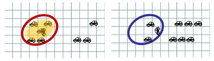
Perimeter control: effect on the mobility without (red) & with the measure (blue)
A research project at TU Delft
Defining a dynamic, time-varying zone for perimeter control is a challenging task, ripe with research questions: where should the zone be? Depending on what measurements? How often should this zone move? Should we have multiple zones? How many vehicles should be allowed in each zone? Nirvana Pecorari, a PhD student at the Transport & Planning department of the TU Delft, dedicates her doctoral studies (3) to answer these questions. Based on state-of-the-art techniques in transport modelling, numerical optimization, computer vision and machine learning, she seeks a solution to this challenging problem. At the core of her research lies powerful simulation software, allowing to measure and assess the impact that dynamic perimeter control has on the mobility ecosystem, so to help design the urban mobility of tomorrow.
(3): Research Project: “Multi-objective dynamic geo-fencing for metropolitan transportation networks” (Pecorari N. PhD Candidate, under the supervision of Rinaldi M., PhD)
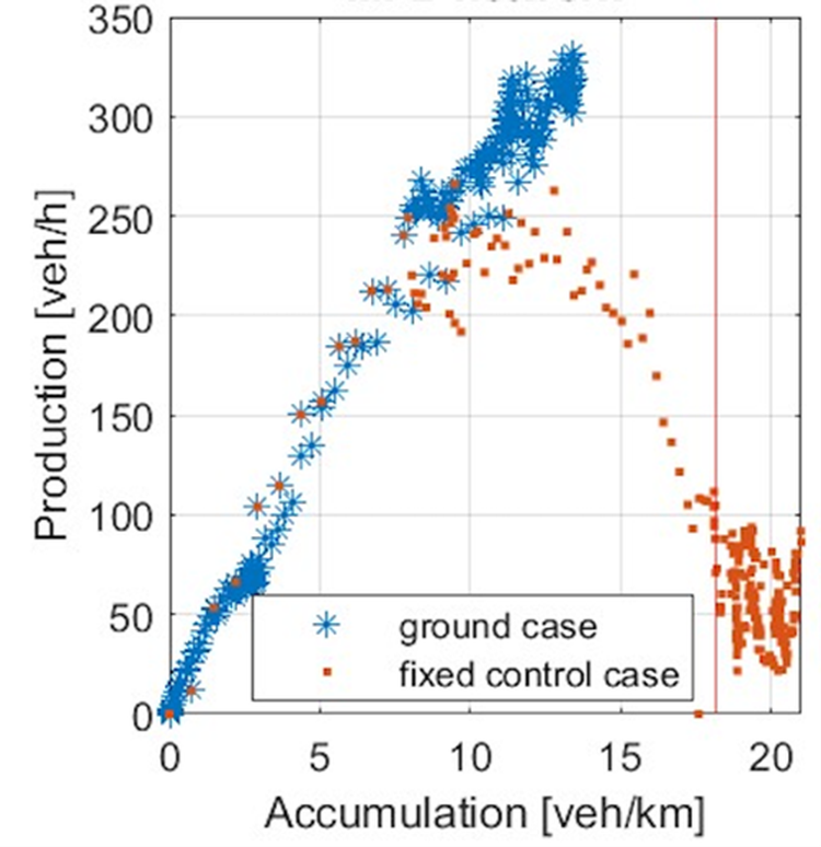
Simulation results: static perimeter control (brown points) leads to undesirable effects (high Accumulation, Low Production = congestion).
Conclusions
Lessons for the future
Mobility in our cities is changing rapidly, bringing both complex challenges and incredible opportunities. A dynamic problem calls for dynamic solutions, we must therefore transition from our historical way of managing mobility, statically and with predefined targets, and instead develop approaches that evolve together with the city’s needs.
Potential
Disruptive technologies such as communication networks, connected vehicles, and AI carry great potential to help support the travelling needs of citizens, while allowing for a safe, clean, healthy, and livable environment. We need concerted, careful action in researching the potential benefits and impacts of these technologies, to make sure they are used fairly and to the greater good.
Integration of Smart Urban Mobility (SUM) and the city of Amsterdam
The needs and ambitions of Amsterdam (4) are well-reflected in the Research & Innovation efforts of the SUM team at AMS Institute. Amsterdam strives for a cleaner, livable future city, where public space is truly public, placing the citizen at its core. Information and data will be essential in enabling a digitally enhanced future mobility management, our recently finalized EIT Urban Mobility project, “Code the Streets” (5), has paved the way for such information exchange. Technological advancements such as geo-fencing play a promising role in enabling this vision, and AMS Institute, TU Delft and the City of Amsterdam continue closely collaborating to reach these ambitious objectives.
“The dynamic use of public space and dynamic policy can lead to safer, more sustainable and more livable neighborhoods. By experimenting with different solutions we can demonstrate the potential of these concepts. The opportunities can be countless!”
Tom Kuipers
Program Developer

Click here to go to the official website of the Code The Streets Project.