Since early times, quay walls in Amsterdam have been built on wooden foundation piles. Some of these structures are over 300 years old. Unfortunately, a large part of them is in poor condition. Due to their great age, proper documentation is often missing. This makes it difficult to know where certain weak spots are or to determine how long a construction will last without intervention. Divers must carry out inspections to calculate the criticality of the structures. These inspections are challenging: visibility below the water surface is only a few centimeters away. Divers may face unknown and potentially dangerous conditions, and low visibility makes it hard to ensure that all destabilizing factors are detected. Although the inspections are challenging, it's crucial to determine the criticality of the quay walls, as recent incidents show. Thus, the question arises: how can we obtain a clear underwater image of the historic quay walls of Amsterdam while minimizing risks during inspections?
Identifying targets in murky water
'Hydrographic survey techniques'—surveys that measure and describe the physical features of bodies of water—provide the means to overcome such shortcomings as they allow to identify targets in murky water while also pointing out locations where in-situ sampling may be possible. This project discusses the suitability of a multibeam echosounder and acoustic camera techniques to inspect the condition of certain parts of the historic quay walls in Amsterdam. The main goal of the surveys was to acquire high-resolution 3D point clouds and visual datasets in order to distinguish (dimensions) of the wooden piles of quay walls.
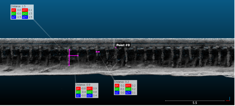
Front view of subsampled 3D point cloud at the Overamstel site indicating free pile length, in-between pile distance and pile diameter
Multibeam echosounder and acoustic camera
The analyses were carried out at two different quay-wall segments at the Houtmankade and Overamstel area during the second half of July 2021. Both segments are representative of the historic quay walls in Amsterdam's city center. The multibeam echosounder was used to acquire high-resolution 3D point clouds below the waterline. The acoustic camera was used to take real-time measurements of quay-wall elements and to obtain detailed visual information. Post-processing of the point cloud and visual datasets enabled distinguishing the quay-wall piles and measuring the dimensions of the quay-wall structural elements.

Multibeam echo sounder

Acoustic camera
“Hydrographic survey techniques such as the multibeam echosounder and acoustic camera help us work towards predictive maintenance of underwater assets”
Pantelis Karamitopoulos
Research Fellow

For this project, we partnered with Deep BV, which specializes in hydrography and geophysics. Deep BV mobilized a vessel that could be used with the execution of our surveys. Deep BV was also responsible for installing, verifying, and calibrating the equipment used in this study and mobilizing personnel and data preparation.
Clear underwater images
This study's results showed that using a multibeam echosounder and an acoustic camera makes it possible to obtain a clear underwater image of the historic quay walls of Amsterdam. The two techniques allowed the acquisition of high-resolution 3D point cloud and visual datasets that, in turn, allowed better identification of the pile rows under the quay wall.
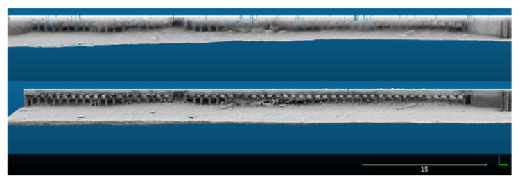
Surveys at the Houtmankade site from 2017 (top) and 2021 (bottom)
A hydrographic survey such as the one in this study may assist the municipality of Amsterdam to:
- Facilitate a complete visual inspection of the current state of the hidden elements of the quay wall structures.
- Set up a monitoring system if the multibeam data are acquired repeatedly over the same area.
- Point out locations where in-situ sampling of the wooden piles of the quays is (not) possible. This knowledge may improve the safety of the divers during their underwater inspections and minimize potential hazards.
- Provide the 3D data necessary to train machine learning models to automate the workflow presented in this study.
Integration of multibeam and photogrammetric point cloud datasets (Houtmankade)
| Duration: |
|
Project members

Pantelis Karamitopoulos
TU Delft
Henk Wolfert
AMS InstitutePartners